Team
Current personnel

Ioannis Manakos, Dr.
Director of Research in ‘Remote Sensing’ at the Information Technologies Institute (ITI) of the Centre for Research and Technology Hellas (CERTH)...

Afroditi Kita, PhD Candidate
Research Assistant at the Information Technologies Institute (ITI) of the Centre for Research and Technology Hellas (CERTH)...

Rizos-Theodoros Chadoulis, PhD Candidate
PhD Candidate co-supervised by the Information Technologies Institute (ITI) of the Centre for Research and Technology Hellas (CERTH)...
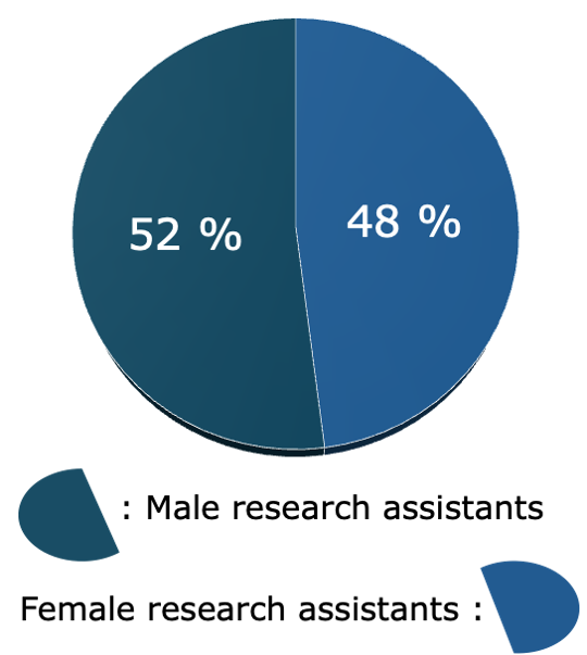
Since 2012 48 personnel units have been engaged in EOS team's activities.
Gender equality target is almost achieved (52% male and 48% female research assistants).
Collaborating personnel (in the framework of direct cooperation within research lines coupled with EOS team's main activities)
* Person 1, Ms.
Detection of aquatic pollutants using Earth Observation data and deep learning techniques
Department of Electrical and Computer Engineering, Aristotle University of Thessaloniki
* Person 2, Mr.
Signal processing - information analysis with application to environmental monitoring
Department of Informatics, Aristotle University of Thessaloniki
* Person 3, Mr.
A methodology for automatic land cover classification using deep learning
Department of Electrical and Computer Engineering, Aristotle University of Thessaloniki
* Person 4, Ms.
Mapping and Evaluation of Riverside Ecosystems and their Ecosystem Services: A Tool for Integrated Management and Sustainable Development in Greece
Department of Biology, School of Natural Sciences, University of Patras
* Person 5, Mr.
A methodology for biodiversity monitoring using remote sensing and ancillary data
Department of Electrical and Electronic Engineering, Imperial College London
* Person 1, Ms.
The assessment of the influence of phenology changes, as approximated by Land Surface Phenology metrics, in relation with the NPP
* Person 2, Mr.
Monitoring water quality variability in the presence of cloud cover using Sentinel-2 imagery: A machine learning approach
* Person 3, Ms.
Water quality monitoring in Kerkini Lake using Earth-Observation data
* Person 4, Ms.
Assessment of Phenology Metrics: Estimation by the use of Landsat and Sentinel-2: A case study in Crete
* Person 5, Ms.
Benefits and challenges of the utilization of Sentinel-1 images for vessel detection
* Person 6, Mr.
Exploitation of spaceborne image content to classify urban/suburban areas
* Person 7, Mr.
Mining information potential from Sentinel optical and Radar data: challenges and limitations mapping land cover
* Person 8, Ms.
Canopy height estimation based on 2-D air- and space-borne imagery supporting terrestrial ecosystem mapping in South Crete
* Person 9, Ms.
Multi-modal knowledge base generation for ecosystem monitoring
* Person 10, Ms.
Multitemporal analysis of the landscape and anthropogenic factors forming the present land use patterns in North West Crete
* Person 11, Mr.
A Machine Learning Based Approach for monitoring harmful algal blooms in inland waterbodies
* Person 12, Ms.
Earth Observation in support of land productivity approximation: the case of Davos, Switzerland
* Person 1, Ms.
Atmospheric correction of Sentinel-2 images using deep learning
Department of Electrical and Computer Engineering, Faculty of Engineering, Aristotle University of Thessaloniki
* Person 2, Mr.
Analysis of optical field of view to support the recreation ecosystem service
Department of Informatics and Telecommunications Engineering, University of Western Macedonia
* Person 3, Mr.
Canopy height estimation from multispectral airborne imagery using machine learning - a Case Study in Bavarian forest
Department of Electrical and Computer Engineering, Faculty of Engineering, Aristotle University of Thessaloniki
* Person 4, Mr., & Person 5, Mr.
Impact study of the fiscal crisis on the urban development using remote sensing data and methods
School of Spatial Planning and Development Engineering of the Polytechnic School at the Aristotle University of Thessaloniki
* = Personal data are anonymized